
Understanding Topographical Land Surveys
Topographical land surveys are foundational to successful planning and development projects across various industries. In a rapidly evolving landscape, professionals in construction, real estate, and environmental planning are increasingly relying on detailed data to make informed decisions. These surveys capture both natural and man-made features of land, creating a comprehensive map that serves as a valuable resource throughout the development process. Whether you are an architect, engineer, or property developer, understanding the importance of topographical land surveys london can significantly enhance your project outcomes.
What is a Topographical Land Survey?
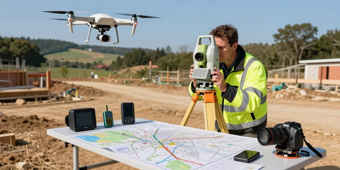
A topographical land survey is a precise mapping of a parcel of land that illustrates the contours, elevations, and features present on the site. This type of survey captures a range of details, from vegetation and buildings to pathways and utilities, providing a detailed representation of the terrain. By employing technologically advanced equipment such as GPS, total stations, and drones, surveyors can achieve a high degree of accuracy in their measurements.
Importance of Topographical Surveys in Project Planning
Topographical surveys serve as the backbone of any development project. They are crucial in providing essential data that informs planning and design, helping to create functional and aesthetically pleasing structures. With this data, architects and engineers can develop designs that integrate seamlessly with the existing landscape, minimizing disruption and environmental impact.
Key Features Captured in a Topographical Survey
- Elevation Changes: Detailed contours that indicate hills, valleys, and slopes, crucial for drainage and structural integrity.
- Natural Features: Mapping existing trees, water bodies, and other significant elements informs landscape design and ecological considerations.
- Man-Made Structures: Buildings, fences, roads, and utilities such as water and electricity lines must be documented to avoid conflicts during the construction phase.
- Boundaries: Accurate delineation of property lines is essential for legal and planning purposes, ensuring projects stay within limits.
Why You Need a Topographical Survey
Before commencing any construction or development, obtaining a topographical survey is critical. It not only aids in design but also serves multiple other purposes essential for smooth project execution. Employers must be aware of the distinct benefits that a topographical survey can provide.
Benefits for Architects and Engineers
For architects and engineers, accurate site data is vital. Topographical surveys provide the foundational information needed to create designs that are appropriate for the terrain. By understanding elevation and existing features, professionals can tailor their plans accordingly, preventing costly alterations later on.
Mitigating Risks in Construction Projects
Construction sites can be fraught with unexpected challenges. Topographical surveys highlight potential hazards, such as unstable ground or flood zones, allowing teams to plan and implement effective risk management strategies. This proactive approach significantly enhances site safety and project viability.
Compliance with Local Planning Regulations
Most local authorities mandate topographical surveys as a part of the planning application process. By providing a clear depiction of the land, these surveys help demonstrate that proposed developments comply with regional regulations and zoning laws, streamlining the approval process.
Who Requires a Topographical Survey?
Topographical surveys are beneficial for a wide range of stakeholders in the construction and real estate sectors. Understanding who requires these services can clarify the importance of the survey in various contexts.
Developers and Construction Companies
Developers and construction companies are among the primary clients for topographical surveying services. Accurate site data is critical for formulating effective construction plans and strategies. This information also supports cost estimation and project scheduling.
Homeowners Planning Extensions or Renovations
For homeowners planning to extend or renovate their properties, a topographical survey can provide essential information about existing structures and boundaries. This ensures that any new developments are compliant with local regulations and that they integrate seamlessly with the surrounding landscape.
Landowners Navigating Property Transactions
Landowners involved in property transactions can benefit significantly from topographical surveys. These surveys clarify property boundaries and provide accurate information that is crucial during negotiations, helping to avoid disputes and ensuring a smooth transaction process.
Modern Equipment Used in Topographical Surveys
The advancement of technology has revolutionized how topographical surveys are conducted. The use of modern equipment enables surveyors to achieve unprecedented accuracy and efficiency in their work.
GPS and GNSS Technologies for Precise Measurements
Global Positioning Systems (GPS) and Global Navigation Satellite Systems (GNSS) have become essential tools in topographical surveying. These technologies allow for rapid and precise point positioning, which is particularly beneficial for larger or more complex sites.
3D Laser Scanners and LiDAR Applications
3D laser scanning, often implemented through Light Detection and Ranging (LiDAR) technology, provides detailed three-dimensional models of terrains. This method can capture millions of data points per second, producing highly accurate representations of the environment, which are invaluable for complex projects.
The Role of Drones in Aerial Surveying
Drones have introduced a new dimension to topographical surveying. Equipped with high-resolution cameras and photogrammetry software, they can access hard-to-reach areas and gather data from above, producing detailed maps with minimal disruption to the site.
Cost Analysis and Pricing of Topographical Surveys
Understanding the cost of topographical surveys is essential for effective budgeting. Several factors influence survey pricing, and developers should be aware of these to make informed choices.
Factors Influencing Survey Costs in the UK
Survey costs can vary significantly based on various factors such as site size, terrain complexity, and the level of detail required. Additional elements like accessibility and the need for special equipment may also impact pricing.
Understanding Price Ranges for Different Projects
As a general guide, small residential plots may cost between £450 and £750, while larger commercial or infrastructure projects can start at £1,500 or more. Surveyors often provide tailored quotes based on specific site characteristics and requirements.
How to Obtain a Free Quote for Your Survey Needs
Most surveying firms offer free online quotes, making it easy to get a grasp on expected costs. Interested parties can send their site details and receive customized pricing and timeframes, helping them plan their projects more effectively.
What are the common uses for topographical surveys?
Topographical surveys are employed in various contexts, including urban and rural planning, environmental assessments, flood risk evaluations, and architectural design. They are critical for ensuring projects are built to standards and that any potential issues are addressed before construction begins.
How long does a topographical survey typically take?
Survey duration can vary depending on site size and complexity. Simple surveys might take just a few hours, while extensive or detailed surveys could span several days or weeks. Engaging professional surveyors can provide clarity on timelines based on project scope.
What types of projects benefit most from topographical surveys?
Projects such as large-scale infrastructure developments, residential estates, commercial buildings, and landscaping ventures typically benefit the most from topographical surveys. They provide essential data that informs design and construction decisions, ensuring that projects are successful.
How can topographical surveys help in risk assessment?
By highlighting features such as elevation changes, flood zones, and environmental constraints, topographical surveys play a crucial role in risk assessment. They allow project teams to identify potential hazards and develop strategies to mitigate risks before they escalate.
What qualifications should a topographical surveyor have?
A qualified topographical surveyor should possess both academic qualifications in surveying or a related field and practical experience in the industry. Relevant certifications and memberships in professional organizations can also indicate competence and adherence to industry standards.